![](/images/other/stat-length.png)
Pas de l'Olan
Marco05
Utilisateur GUIDE
![Longueur](/images/other/stat-length.png)
![Altitude max](https://static1.geolcdn.com/siteimages/upload/files/1508320355ic_sort_altitude_max_24dp.png)
![Dénivelé positif](https://static1.geolcdn.com/siteimages/upload/files/1508320355ic_sort_den_pos_24dp.png)
![Km-Effort](/images/other/stat-length.png)
![Altitude min](https://static1.geolcdn.com/siteimages/upload/files/1508320355ic_sort_altitude_min_24dp.png)
![Dénivelé négatif](https://static1.geolcdn.com/siteimages/upload/files/1508320355ic_sort_den_neg_24dp.png)
![Boucle](https://static1.geolcdn.com/siteimages/upload/files/16400158638029165_repeat_loop_refresh_sync_direction_icon.png)
![Marche](https://static1.geolcdn.com/sitytour/trail-icons/101.png)
7h37
Difficulté : Très difficile
![Scannez ce code QR pour ouvrir la randonnée dans l'application SityTrail](https://capi.geolives.com/qq0zvz2zws4bq2lad0pu/sitytour/trails/3181009/qr.png?size=200)
Application GPS de randonnée GRATUITE
À propos
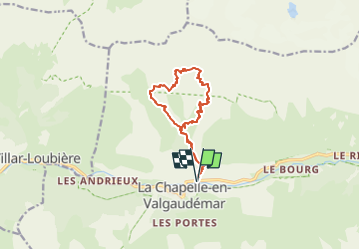
Randonnée Marche de 12,6 km à découvrir à Provence-Alpes-Côte d'Azur, Hautes-Alpes, La Chapelle-en-Valgaudémar. Cette randonnée est proposée par Marco05.
Description
Longue randonnée au départ de la Chapelle en Valgaudemar.
Le départ se situe à la sortie de la Chapelle, en direction du Gioberney.
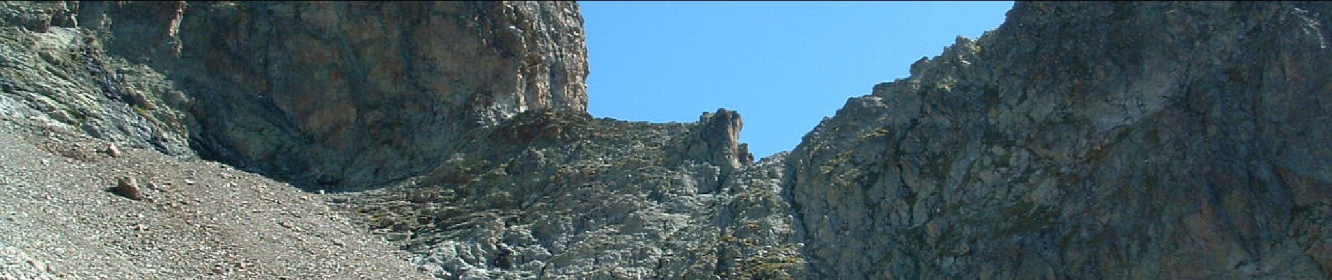
Attention, le dénivelé et la descente du pas de l'Olan sont réservés à des randonneurs chevronnés et endurants.
A la montée on peut faire une halte au refuge de l'Olan.
Localisation
Commentaires
Randonnées à proximité
![Marche Marche](https://static1.geolcdn.com/sitytour/trail-icons/101.png)
Marche
![](/images/other/stat-length.png)
![](https://static1.geolcdn.com/siteimages/upload/files/16400158638029165_repeat_loop_refresh_sync_direction_icon.png)
![Randonnée Marche La Chapelle-en-Valgaudémar - circuit de la cabane de l'aup .08-06-14 - Photo](https://media.geolcdn.com/t/375/260/ext.jpg?maxdim=2&url=https%3A%2F%2Fservices.sitytrail.com%2FGeolivesWS%2FDownloadMedia.ashx%3FTrailID%3D310408%26Media%3Dfix__20140608140628.jpg)
![Marche Marche](https://static1.geolcdn.com/sitytour/trail-icons/101.png)
Marche
![](/images/other/stat-length.png)
![](https://static1.geolcdn.com/siteimages/upload/files/16400158638029165_repeat_loop_refresh_sync_direction_icon.png)
![Randonnée Marche La Chapelle-en-Valgaudémar - Tour du Vieux Chaillol 2/5 - Du Gîte Le Casset au Refuge de Vallonpierre - Photo](https://media.geolcdn.com/t/375/260/ext.jpg?maxdim=2&url=https%3A%2F%2Fservices.sitytrail.com%2FGeolivesWS%2FDownloadMedia.ashx%3FTrailID%3D110181%26Media%3D5395_2.jpg)
![Marche Marche](https://static1.geolcdn.com/sitytour/trail-icons/101.png)
Marche
![](/images/other/stat-length.png)
![](https://static1.geolcdn.com/siteimages/upload/files/16400158638029165_repeat_loop_refresh_sync_direction_icon.png)
![Randonnée Marche Villar-Loubière - Pic Turbat - Photo](https://media.geolcdn.com/t/375/260/d62b8d76-41e7-46f4-8b33-5d2b5ae47cbd.jpg&format=jpg&maxdim=2)
![Marche Marche](https://static1.geolcdn.com/sitytour/trail-icons/101.png)
Marche
![](/images/other/stat-length.png)
![](https://static1.geolcdn.com/siteimages/upload/files/16400158638029165_repeat_loop_refresh_sync_direction_icon.png)
![Randonnée Marche La Chapelle-en-Valgaudémar - Lacs de Pétarel - Photo](https://media.geolcdn.com/t/375/260/5e28ea7d-88f9-46a3-ba95-03bb6ef09059.jpg&format=jpg&maxdim=2)
![Marche Marche](https://static1.geolcdn.com/sitytour/trail-icons/101.png)
Marche
![](/images/other/stat-length.png)
![](https://static1.geolcdn.com/siteimages/upload/files/16400158638029165_repeat_loop_refresh_sync_direction_icon.png)
![Randonnée Marche La Chapelle-en-Valgaudémar - La Chapelle-en-Valgaudémar - les Portes - AR sur le GRP en forêt - 4.3km 285m 1h40 - 2018 07 05 - Photo](https://media.geolcdn.com/t/375/260/ext.jpg?maxdim=2&url=https%3A%2F%2Fservices.sitytrail.com%2FGeolivesWS%2FDownloadMedia.ashx%3FTrailID%3D999071%26Media%3Dfix__20180705073135.jpg)
![Marche Marche](https://static1.geolcdn.com/sitytour/trail-icons/101.png)
Marche
![](/images/other/stat-length.png)
![](https://static1.geolcdn.com/siteimages/upload/files/16400158638029165_repeat_loop_refresh_sync_direction_icon.png)
![Randonnée Marche La Chapelle-en-Valgaudémar - La Chapelle-en-Valgaudémar - Vallon de la Navette - 10.9km 410m 4h30 - 2018 06 30 - Photo](https://media.geolcdn.com/t/375/260/ext.jpg?maxdim=2&url=https%3A%2F%2Fservices.sitytrail.com%2FGeolivesWS%2FDownloadMedia.ashx%3FTrailID%3D998812%26Media%3Dfix__20180630163125.jpg)
![Marche Marche](https://static1.geolcdn.com/sitytour/trail-icons/101.png)
Marche
![](/images/other/stat-length.png)
![](https://static1.geolcdn.com/siteimages/upload/files/16400158638029165_repeat_loop_refresh_sync_direction_icon.png)
![Randonnée Marche La Chapelle-en-Valgaudémar - La Chapelle-en-Valgaudémar - AR sur GR54 Vallée de la Séveraisse jusqu'au Refuge du Clot - 15.9km 450m 5h55 (50mn) - 2018 07 01 - Photo](https://media.geolcdn.com/t/375/260/ext.jpg?maxdim=2&url=https%3A%2F%2Fservices.sitytrail.com%2FGeolivesWS%2FDownloadMedia.ashx%3FTrailID%3D998805%26Media%3Dfix__20180701095057.jpg)
![Marche Marche](https://static1.geolcdn.com/sitytour/trail-icons/101.png)
Marche
![](/images/other/stat-length.png)
![](https://static1.geolcdn.com/siteimages/upload/files/16400158638029165_repeat_loop_refresh_sync_direction_icon.png)
![Randonnée Marche La Chapelle-en-Valgaudémar - Vallée de la Séveraisse - AR sur le GR54 du Rif du Sap jusqu'au Clot - 6km 190m 2h20 - 2018 07 04 - Photo](https://media.geolcdn.com/t/375/260/ext.jpg?maxdim=2&url=https%3A%2F%2Fservices.sitytrail.com%2FGeolivesWS%2FDownloadMedia.ashx%3FTrailID%3D998794%26Media%3Dfix__20180704131615.jpg)
![Marche Marche](https://static1.geolcdn.com/sitytour/trail-icons/101.png)
Marche
![](/images/other/stat-length.png)
![](https://static1.geolcdn.com/siteimages/upload/files/16400158638029165_repeat_loop_refresh_sync_direction_icon.png)